
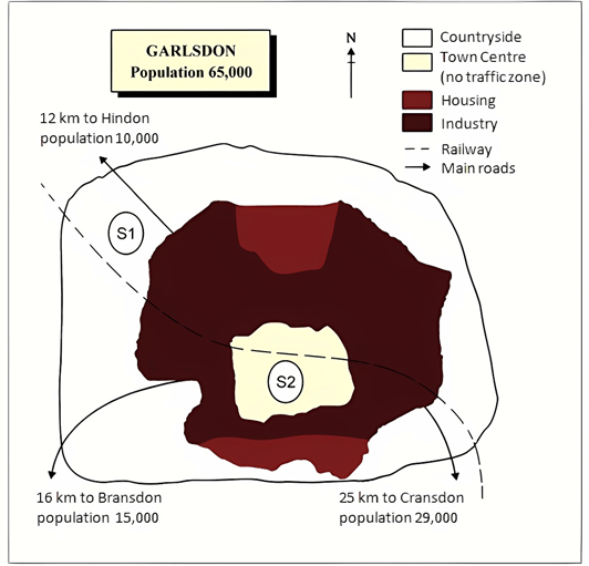
5+ The map below is of the town of Garlsdon. A new supermarket (S) is planned for the town
The map below is of the town of Garlsdon. A new supermarket (S) is planned for the town. The map shows two possible sites for the supermarket. Summarise the information by selecting and reporting the main features, and make comparisons where relevant. Write at least 150 words hay nhất giúp bạn có thêm tài liệu tham khảo để viết bài luận bằng Tiếng Anh hay hơn.
- The map below is of the town of Garlsdon. A new supermarket (S) is planned for the town (mẫu 1)
- The map below is of the town of Garlsdon. A new supermarket (S) is planned for the town (mẫu 2)
- The map below is of the town of Garlsdon. A new supermarket (S) is planned for the town (mẫu 3)
- The map below is of the town of Garlsdon. A new supermarket (S) is planned for the town (mẫu 4)
- The map below is of the town of Garlsdon. A new supermarket (S) is planned for the town (mẫu 5)
- The map below is of the town of Garlsdon. A new supermarket (S) is planned for the town (mẫu 6)
- The map below is of the town of Garlsdon. A new supermarket (S) is planned for the town (mẫu 7)
- The map below is of the town of Garlsdon. A new supermarket (S) is planned for the town (mẫu 8)
- The map below is of the town of Garlsdon. A new supermarket (S) is planned for the town (mẫu 9)
- The map below is of the town of Garlsdon. A new supermarket (S) is planned for the town (mẫu 10)
- The map below is of the town of Garlsdon. A new supermarket (S) is planned for the town (mẫu 11)
- The map below is of the town of Garlsdon. A new supermarket (S) is planned for the town (mẫu 12)
- The map below is of the town of Garlsdon. A new supermarket (S) is planned for the town (mẫu 13)
- The map below is of the town of Garlsdon. A new supermarket (S) is planned for the town (mẫu 14)
- The map below is of the town of Garlsdon. A new supermarket (S) is planned for the town (mẫu 15)
- The map below is of the town of Garlsdon. A new supermarket (S) is planned for the town (mẫu 16)
- The map below is of the town of Garlsdon. A new supermarket (S) is planned for the town (mẫu 17)
- The map below is of the town of Garlsdon. A new supermarket (S) is planned for the town (mẫu 18)
- The map below is of the town of Garlsdon. A new supermarket (S) is planned for the town (mẫu 19)
- The map below is of the town of Garlsdon. A new supermarket (S) is planned for the town (mẫu 20)
- The map below is of the town of Garlsdon. A new supermarket (S) is planned for the town (mẫu 21)
- The map below is of the town of Garlsdon. A new supermarket (S) is planned for the town (mẫu 22)
5+ The map below is of the town of Garlsdon. A new supermarket (S) is planned for the town
Đề bài: The map below is of the town of Garlsdon. A new supermarket (S) is planned for the town. The map shows two possible sites for the supermarket. Summarise the information by selecting and reporting the main features, and make comparisons where relevant. Write at least 150 words.
The map below is of the town of Garlsdon. A new supermarket (S) is planned for the town - mẫu 1
The given map shows two possible locations for the planned supermarket in Garsdon City. As is presented in the illustration, the city has a population of more than 65 thousand and the two possible locations for the supermarket are near Hindon area and in the middle of the industrial area.
Overall, the first location (S1) would be both away from the town centre and out of the crowd, which would be more convenient for the citizens of Hindson area, while the second location (S2) would be advantageous for the people of Bransdon and Cransdon area.
According to the map, the railway surrounds the city and intersects the city almost in the middle. There are main roads for transportation and countryside surrounds the main housings and industries of the city. The housing of the city is mainly in the North and South sides of the city and the town centre is in the middle of the industrial area. The first possible location for the planned supermarket is near the Hindon area where almost ten thousand inhabitants live, and the location is in the north-west corner. This location would be ideal for the Hindon people for shopping but the people of Crandon and Brandon, which have great more population, would be far away from this supermarket. The second possible location which is almost in the centre of the city would be surrounded by industrial zones and housings in the North and South sides of the city. This would be an ideal place as it would connect all the shoppers in the three parts of the city. Since the railway passes near this location, this would be a better place in terms of communication as well.
The map below is of the town of Garlsdon. A new supermarket (S) is planned for the town - mẫu 2
The illustration gives information on the possible places to construct a supermarket in Garlsdon. Overall, it is clearly shown that one of the possible sites of a supermarket is in the countryside while the other in the town centre.
Firstly, it is apparent that the first site of the supermarket (S1) is located in the countryside, where it is far away from the town centre and residential places. However, it is reachable by the public from the town centre and their housing areas by train and other transport on roads as there are a railway track and the main road connecting the supermarket and town centre. In addition, although it is located near to Hendon, its location is far away from Bransdon and Gransdon which have a higher population than Hindon.
Turning to the second possible site of the supermarket (S2), it is apparent that it is situated in the centre of the town where every citizen in the town can easily access. It is fairly convenient for those living in Hindon and Gransdon as there are two ways to reach it, either by train or through the main roads. On the other hand, those from Bransdon can only visit the supermarket through the main road.
The map below is of the town of Garlsdon. A new supermarket (S) is planned for the town - mẫu 3
The cartographic depiction centers on Garlsdon, a town populated by 65,000 individuals, and highlights two prospective locales for a new supermarket.
An overview of the town’s geography indicates that the first proposed site, S1, is situated towards the northwest border, while the central site, S2, is nestled within an industrial belt. These sites differ markedly in their proximity to residential areas and transport links, hinting at distinct advantages for the town of Garlsdon's diverse demographic.
Examining the details, site S1 finds itself adjacent to the outskirts, 12 kilometers from Hindon. This location promises a tranquil shopping environment for its 10,000 denizens, away from the urban buzz. However, its distance from the more populous regions of Bransdon and Cransdon, which lie 16 and 25 kilometers away respectively, might limit its accessibility for a considerable number of the town of Garlsdon's residents.
Conversely, site S2 offers a centralized position, potentially serving as a commercial nexus in the town of Garlsdon. Surrounded by the main roads and with the railway bisecting the vicinity, it stands to benefit from superior connectivity. This central site is poised to cater not only to the immediate industrial zone but also to the residential zones to the north and south, thus bridging the gap between different sectors of the town of Garlsdon.
The map below is of the town of Garlsdon. A new supermarket (S) is planned for the town - mẫu 4
The illustrative map delineates Garlsdon, a town with a population of 65,000, assessing two potential sites for the establishment of a new supermarket.
At a glance, the proposed sites, labelled S1 and S2, are positioned at opposing ends of the town of Garlsdon, each with distinct geographic and demographic implications. S1 is peripherally located, while S2 is at the urban core, adjacent to the industrial sector.
Site S1, on the northwest outskirts near Hindon, seems tailored for the town of Garlsdon's residents who prefer shopping away from the bustling city center. With Hindon's population of 10,000, this site could serve as a convenient option for the locals there, albeit less so for those in Bransdon and Cransdon, situated 16 and 25 kilometers away, respectively.
In contrast, the centrally located S2 is within the industrial heart of the town of Garlsdon, promising easy access for a greater number of residents. Its proximity to the railway and arterial roads enhances its accessibility, potentially drawing shoppers from across the town of Garlsdon. This site, therefore, stands out as a confluence point for consumers from the northern and southern residential belts as well as the adjacent urban areas.
The map below is of the town of Garlsdon. A new supermarket (S) is planned for the town - mẫu 5
The map proffers an analysis of two prospective locations for a supermarket in the bustling town of Garlsdon, which is home to a considerable populace of 65,000.
The initial observation of the map underscores two salient points: the positioning of the proposed sites S1 and S2 in relation to the town's infrastructure and the potential impact on the town of Garlsdon's citizenry. S1 is placed on the outskirts, whereas S2 is situated centrally, each with its unique connectivity and reach.
Site S1 is on the northwestern fringe, near Hindon, which could serve as a retail oasis for the town of Garlsdon's suburban population, particularly for the 10,000 residents of Hindon. Its seclusion from Bransdon and Cransdon, however, might render it less accessible for their combined population of 44,000.
Conversely, site S2 is enveloped by the town's industrial heartbeat, rendering it a potential commercial hub for the town of Garlsdon. The railway and main roads cradle S2, augmenting its accessibility and promising a convergence of shoppers from all corners of the town. For the industrious and residential communities flanking the north and south, S2 could be the epitome of convenience.
The map below is of the town of Garlsdon. A new supermarket (S) is planned for the town - mẫu 6
The map illustration provides a comparative analysis of two potential sites for a forthcoming supermarket in the town of Garlsdon, a settlement home to 65,000 residents. The primary focus of the sites is on convenience and accessibility for the local populace.
The overarching detail of the map is the strategic placement of the two sites in relation to the town’s main features. The first site, designated S1, is positioned on the periphery near Hindon, offering a less congested environment potentially favoring the residents of that locality. In contrast, the second site, marked as S2, lies centrally, ensconced within the industrial zone, potentially serving a broader segment including Bransdon and Cransdon.
Delving into the specifics, site S1 is located northwest of the town center, adjacent to the countryside, thereby offering ease of access for the 10,000 Hindon residents. Its relative remoteness from the central urban hustle could be perceived as a drawback or a benefit depending on the perspective. On the other hand, site S2 is advantageously situated at the heart of the town, encircled by the industrial zone and residential areas. Its proximity to the railway and the main thoroughfares could render it a logistical hub, facilitating easy ingress and egress for shoppers from various parts of the town of Garlsdon.
The map below is of the town of Garlsdon. A new supermarket (S) is planned for the town - mẫu 7
The map illustrates two proposed locations for the construction of a new supermarket in the town of Garlsdon.
The first potential location (S1) is outside the town itself and is sited just off the main road to the town of Hindon, lying 12 kms to the north-west. This site is in the countryside and so would be able to accommodate a lot of car parking. This would make it accessable to shoppers from both Hindon and Garlsdon who could travel by car. As it is also close to the railway line linking the who towns to Cransdon (25 km to the south-east), a potentially large number of shoppers would also be able to travel by train.
In contrast, the suggested location, S2, is right in the town centre, which would be good for local residents. Theorically the store could be accessed by road or rail from the surrounding towns, including Bransdon, but as the central area is a non-traffic zone, cars would be unable to park, and access would be difficult.
Overall, neither site is appropriate for all the towns, but for customers in Cransdon, Hindon and Garlsdon, the out-of-town site (S1) would probably offer more advantages.
The map below is of the town of Garlsdon. A new supermarket (S) is planned for the town - mẫu 8
The given map depicts two proposed supermarkets in a town of 65000 residents, which is called Garlsdon.
The first supermarket is located in the industrial area in the north between the main road and railway track towards Hindon, which is 12 km from the existing town and has a population of 10,000 people. This supermarket will mostly cater to the people of the countryside and travelers due to its unique position among the wayside of rail and road tracks.
The second supermarket is in the town center, which is surrounded by housing and at the center of the two opposite industrial regions. The supermarket will incur more business as it is on the way to Bransdon and Cransdon, which are 16km and 25km apart, respectively. However, the rail track has very close proximity.
The first supermarket can expect fewer customers due to its location in the countryside where not much housing falls. But the second one can expect good business as it is relatively in the middle of the town and among the complex housing. The advantage of being on the highway near the rail track is that it can attract more customers.
The map below is of the town of Garlsdon. A new supermarket (S) is planned for the town - mẫu 9
The map depicts information about the proposed new supermarket that is to be constructed in Garlsdon town.
Overall, it can be seen that there are three small villages that surround Garlsdon town. Housing dominates most of the region of the town while the railway passes through the whole village.
To begin with, the countryside is surrounded by many houses. To the north side of Hindon village is an industry. The southern part of Bramdon and Cramsdon is also an industry.
Furthermore, the town center is surrounded by houses. The railway passed from Hindon village across Cromsdon countryside. Also, the main road starts from Hindon village and leads to the Town center. The three main roads lead to the town center.
The map below is of the town of Garlsdon. A new supermarket (S) is planned for the town - mẫu 10
The map shows two potential locations (S1 and S2) for a new supermarket in a town called Garlsdon.
The main difference between the two sites is that S1 is outside the town, whereas S2 is in the town centre.
The sites can also be compared in terms of access by road or rail, and their positions relative to three smaller towns. Looking at the information in more detail, S1 is in the countryside to the northwest of Garlsdon, but it is close to the residential area of the town. S2 is also close to the housing area which surrounds the town centre.
There are main roads from Hindon, Bransdon and Cransdon to Garlsdon town centre, but this is a no traffic zone, so there would be no access to S2 by car. By contrast, S1 lies on the main road to Hindon, but it would be more difficult to reach from Bransdon and Cransdon. Both supermarket sites are close to the railway that runs through Garlsdon from Hindon to Cransdon.
The map below is of the town of Garlsdon. A new supermarket (S) is planned for the town - mẫu 11
The map displays two locations for the construction of a supermarket in Garlsdon. As indicated in the map, the city has a population of 65,000. From an overall perspective, we find that the locations identified for the supermarket are in the countryside near Hindon and the town centre near Bransdon and Cransdon.
From a closer inspection of the map, it is evident that the first site in the north-west, located near Hindon, which has a population of 10,000, would be away from the industrial and housing areas. However, it is well-connected to these areas by road and rail. But we have to consider the fact that though it is in close proximity to Hindon, it is quite far away from Bransdon and Cransdon which are densely populated.
The second site is located at the heart of the city and is surrounded by industrial areas. It is 16km from Bransdon and 25 km from Cransdon. It is connected to Hindon and Cransdon by road and rail whereas people of Bransdon can only use the road.
The map below is of the town of Garlsdon. A new supermarket (S) is planned for the town - mẫu 12
The map shows two proposed sites for a supermarket that will be built in the town of Garlsdon. The main difference between these sites is that the first location is just outside the town, while the other is located in the town centre.
The first proposed supermarket location (S1) is situated to the northwest of Garlsdon, in the countryside that surrounds the town. It is not far from a residential area, and is near a main road leading to Hindon, a much smaller town than Garlsdon. It is also close to a train track running through the middle of town.
In contrast, the second possible supermarket site (S2) is located right in the middle of Garlsdon, in the town centre. Although there is no traffic permitted in this area, it is not far from two different housing areas. There is also a train track close by and several main roads leading to other smaller towns with populations less than half that of Garlsdon.
The map below is of the town of Garlsdon. A new supermarket (S) is planned for the town - mẫu 13
The map illustrates two potential locations for building a new supermarket in the town of Garlsdon.
Overall, site one (S1) is situated on the north side in the countryside area whereas the second site (S2) is located on the south, in the center of town near to surrounded by residential area.
Garlsdon is a town with a population of 65000. A railway line intersects the city almost in the middle, passing through town center. Two main roads branch out from east and west of the town center connecting to two nearby cities at a distance of 16 km and 25 km, that is Bransdon and Cransdon respectively. The city has houses constructed in all directions, except in the middle north and south where an exclusive industrial zone is built. The first prospective location for the supermarket is in the outskirts of the city, in countryside near the Hindon area which is 12kilometere from the town center with a population of ten thousand. This location is in the northwest corner.
The second possible location is almost in the center of the city that is surrounded by housing in all the sides and industrial zones in the north and south of the city. A railway line and main road passes through this site, making it fairly convenient for people of neighboring cities.
The map below is of the town of Garlsdon. A new supermarket (S) is planned for the town - mẫu 14
As we can see from the map of town Garlsdon where a new supermarket is about to be established soon.
The total population of the town is 65,000, and we will be discussing the two possible outcomes for the site to be planned.
To begin with, the first plan is covering the countryside area where there is the least population which in result will lead to less crowd and ample of space for parking your vehicles. With that said, the population of the countryside is nearly 10,000 and is 12 KM away from Hindon.
Secondly, the other plan is exactly the opposite of the first one, which is featuring in the middle of the town surrounding the industries. Moreover, the site is no traffic zone which will also make it eco-friendly and greener due to less pollution. To add further, the site is at 16KM away from Brandson with a population of 15,000 and 25 KM away from Cransdon with a population of 29,000, which makes it a prime location for more business.
To conclude, the second site plan suits me the most as it is in the prime location with a larger population covering which will profit the supermarket in terms of business.
The map below is of the town of Garlsdon. A new supermarket (S) is planned for the town - mẫu 15
The map illustrates the layout of Garlsdon, a town with a, Bransdon, and Cransdon. The town is characterized by distinct zones for housing and industry, separated by main roads and a railway.
In the heart of Garlsdon lies the town centre (S2), a no traffic zone surrounded by an extensive housing area marked as S1. This residential zone is well-connected by main roads that form an intricate network facilitating easy transportation. The industrial area is strategically located to the north-west, ensuring that residential zones remain unaffected by industrial activities.
Garlsdon’s proximity to neighbouring towns is noteworthy. Hindon, with 10,000 residents, is just 12 km away while Bransdon (15,000 residents) and Cransdon (29,000 residents) are situated at distances of 16 km and 25 km respectively. These towns are connected to Garlsdon via main roads ensuring seamless connectivity.
The planning of Garlsdon reflects thoughtful zoning, ensuring that residential areas are well-separated from industrial zones yet connected efficiently through main roads. Its strategic location in proximity to neighbouring towns augments its connectivity and accessibility.
The map below is of the town of Garlsdon. A new supermarket (S) is planned for the town - mẫu 16
The provided map delineates the geographical layout of Garlsdon along with its adjacent towns - Hindon, Bransdon, and Cransdon - highlighting their populations as well as infrastructural elements like housing areas, industries, railways and main roads.
Garlsdon boasts a significant population of 65k inhabitants residing primarily in the expansive housing sector labelled S1 on the map. This sector encircles the town centre (S2), which interestingly is designated as a no-traffic zone enhancing pedestrian safety and environmental quality within this core area.
A railway line skirts around these central sectors providing essential connectivity while also demarcating them from the surrounding countryside which hosts smaller towns like Hindon with 10k people at a distance of 12km; Bransdon home to 15k individuals positioned 16km away; and Cransdor accommodating a populace of 29k located further off at 25km from Garlsodon.
This meticulous urban planning ensures not only efficient space utilization but also fosters enhanced inter-town connectivity while preserving tranquility within residential quarters amidst bustling urban life.
The map below is of the town of Garlsdon. A new supermarket (S) is planned for the town - mẫu 17
The map below shows the two possible locations for the planned supermarket in Garlsdon City.
Overall, it can be seen that with the passage of time, the supermarket in Garlsdon went through a revolutionary change, and the undeveloped area was equipped with simple and modern amenities.
The first site of the supermarket (SI) is located on the east side. The town center is situated in the middle of the area, and the housing is mainly located on the north side of the supermarket. A railway track and a road connect the supermarket and the town center.
Turning to the (S2) supermarket, it is located in the heart of town and is easily accessible to all residents. It is fairly convenient for those who live in Brandson and Cransdon as there are two ways to get there: by train or on the main road. On the other hand, people in Bransdon can only access the supermarket using the main road. Garlsdon residents also have other options for getting to the supermarket now that it has been developed.
The map below is of the town of Garlsdon. A new supermarket (S) is planned for the town - mẫu 18
Two planned supermarkets are shown on the provided map of Garlsdon, a town of 65,000 people.
Situated 12 km from the current town and home to 10,000 people, the first supermarket is situated in the industrial area towards the north, between the main road and the railway track towards Hindon. Because of its unusual location next to the railroad and road tracks, this supermarket will primarily serve rural residents and tourists.
Situated in the middle of the two opposing industrial regions and encircled by residential areas is the town center, where the second supermarket is located. Since the supermarket is en route to Bransdon and Cransdon, which are located 16 and 25 kilometers apart, respectively, it will see an increase in business. But the railroad tracks are very close by.
Due to its rural location and lack of housing, the first supermarket should anticipate a decrease in patronage. However, given its location in the middle of the town and among complex housing, the second one can anticipate strong business. The benefit of having a rail track next to the highway is that it can draw in more business.
The map below is of the town of Garlsdon. A new supermarket (S) is planned for the town - mẫu 19
The map displays two possible locations, S1 and S2, for a new supermarket, which is planned for a town named Garlsdon.
Overall, it can be seen that there are plans to build the supermarket either at location S1, which is a rural area, or at S2, in the centre of the town. Moreover, both locations will be accessible by rail or road.
Looking at one of the possible positions, S1, if the supermarket were to be constructed here, it would be in the northwestern part of the town, which is a countryside area. It would be located between the railway line and the main road that connects to Hindon, which is 12 km away from the town centre and has a population of 10,000.
Focusing on S2, if constructed at this location, the supermarket would be in the town centre, encircled by a residential area. This area is accessible only by rail, and as this part is for pedestrians only, vehicles are not allowed here. Nevertheless, one road links this area to Bransdon in the southwest, a town 16 km away with 15000 people, and the other to Cransdon, which is 25 km southeast and is home to 29000 inhabitants.
The map below is of the town of Garlsdon. A new supermarket (S) is planned for the town - mẫu 20
The map depicts two prospective locations (S1 and S2) for a new supermarket in a town called Garlsdon.
The chief difference between the two sites is that S1 is on the outskirts of the town, while S2 is in the town centre. The sites can also be compared in terms of access by road or rail, and their positions relative to three smaller towns named Hindson, Bransdon and Cransdon.
A thorough glance at the map reveals that S1 is in the countryside to the northwest of Garlsdon, but it is also in proximity to the residential area of the town. S2 is also close to the housing area, which palisades the town centre.
Probing further, there are main roads from Hindon, Bransdon and Cransdon to Garlsdon town centre, but this is a no traffic zone, so there would be no access to S2 by car. By contrast, S1 lies on the main road to Hindon, but it would be more challenging to access from Bransdon and Cransdon. Both supermarket locations are close to the railway that runs through Garlsdon from Hindon to Cransdon. Furthermore, the Industrial area in the South end of Garlsdon is closer to S2 than the Industrial area lying in the North region of Garlsdon which is a little farther from S1.
The map below is of the town of Garlsdon. A new supermarket (S) is planned for the town - mẫu 21
The map shows the town of Garlsdon which has an overall population of 65,000. There were two locations planned to construct a new supermarket for the town.
The map gives information about the sites of the supermarket where one is located in the countryside and the other is located in the town centre.
Site 1 of the supermarket is situated away from the town centre which is majorly covered by industries. There is no housing nearby, however, those people can reach here by train and transport. The site is between the railway line and a main road. This site is commutable only by the Hindon people rather than the Brandson and Grandson people who are more in population.
While looking at the second possible site of the supermarket, it is clear that the site is situated in the centre of the town. It is easily reachable by the Brandson and Grandson people and also by the people living in Hindon by train and from the main road. As this site is located near the residential area it is way more convenient for people to access.
The map below is of the town of Garlsdon. A new supermarket (S) is planned for the town - mẫu 22
The map shows a town of 65,000 people called Garlsdon. Indicated on the map are two potential locations for a new supermarket in the town.
In general, it can be seen that the first site, S1, is in a more rural area on the outskirts of town, while the second location, S2, occupies a more urban and central position in the town.
Focusing on S1, if the supermarket were placed here, it would be positioned in the north-west of the countryside between the railway line and the main road to Hindon, a town 12km away with a population of 10,000.
If built on the S2 site, however, the supermarket would be just south of the railway track within the pedestrianised town centre, which itself is encircled by a residential area. To the west and east of the supermarket would be the roads to Bransdon and Cransdon respectively. Whereas the former is 16km southwest and holds 15,000 people, the latter is 25km southeast and is home to 29,000 inhabitants.
Xem thêm các bài luận Tiếng Anh hay khác:

TÀI LIỆU CLC DÀNH CHO GIÁO VIÊN VÀ PHỤ HUYNH LỚP 9
+ Bộ giáo án, bài giảng powerpoint, đề thi file word có đáp án 2025 tại https://tailieugiaovien.com.vn/
+ Hỗ trợ zalo: VietJack Official
+ Tổng đài hỗ trợ đăng ký : 084 283 45 85
Đã có app VietJack trên điện thoại, giải bài tập SGK, SBT Soạn văn, Văn mẫu, Thi online, Bài giảng....miễn phí. Tải ngay ứng dụng trên Android và iOS.


Nếu thấy hay, hãy động viên và chia sẻ nhé! Các bình luận không phù hợp với nội quy bình luận trang web sẽ bị cấm bình luận vĩnh viễn.
- Đề thi lớp 1 (các môn học)
- Đề thi lớp 2 (các môn học)
- Đề thi lớp 3 (các môn học)
- Đề thi lớp 4 (các môn học)
- Đề thi lớp 5 (các môn học)
- Đề thi lớp 6 (các môn học)
- Đề thi lớp 7 (các môn học)
- Đề thi lớp 8 (các môn học)
- Đề thi lớp 9 (các môn học)
- Đề thi lớp 10 (các môn học)
- Đề thi lớp 11 (các môn học)
- Đề thi lớp 12 (các môn học)
- Giáo án lớp 1 (các môn học)
- Giáo án lớp 2 (các môn học)
- Giáo án lớp 3 (các môn học)
- Giáo án lớp 4 (các môn học)
- Giáo án lớp 5 (các môn học)
- Giáo án lớp 6 (các môn học)
- Giáo án lớp 7 (các môn học)
- Giáo án lớp 8 (các môn học)
- Giáo án lớp 9 (các môn học)
- Giáo án lớp 10 (các môn học)
- Giáo án lớp 11 (các môn học)
- Giáo án lớp 12 (các môn học)


 Giải bài tập SGK & SBT
 Tài liệu giáo viên
 Sách
Sách
 Khóa học
 Thi online
 Hỏi đáp